Currently, Webster Boulevard north of Innisfil Beach Road ends in a cul-de-sac.
The two dozen or so homes with driveways that front onto Webster North basically have the wide street to themselves – but that will change in the future.
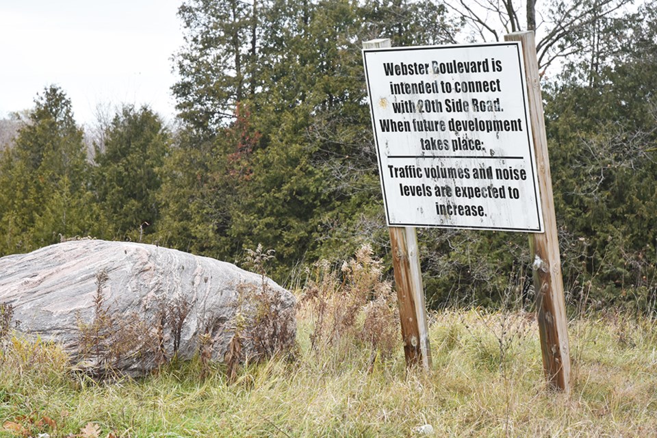
A sign posted at the cul-de-sac warns, ‘Webster Boulevard is intended to connect with 20th Sideroad when future development takes place. Traffic volumes and noise levels are expected to increase.’
That future could be close. In 2020, the Town of Innisfil retained B.T. Engineering Inc. to carry out a municipal class Environmental Assessment for the Webster Boulevard extension.
The engineers have now completed and posted the Environmental Study Report (ESR), outlining a preferred route, a preferred intersection design at Sideroad 20; and a preferred cross-section for the new roadway.
The ESR predicts that once the connection is completed, traffic on Webster could reach 3,000 vehicles per day.
The northern extension of Webster Boulevard has long been part of the Town of Innisfil’s infrastructure plans – recommended in both the 2018 Transportation Master Plan Update, and the town’s Official Plan, which identified Webster as a ‘future major collector road.’
"The extension of Webster Boulevard to 20th Sideroad has been part of the road network through Alcona for many years," said the town's development engineer, Suzanna Nilsson. "It was discussed in the Alcona North Secondary Plan (2011), the 2013 Transportation Master Plan, and the 2018 Transportation Master Plan Update."
The sign at the cul-de-sac has been in place "since at least 2017 when the area development was assumed by the town," she said.
The idea is to divert traffic away from the intersection of Sideroad 20 and Innisfil Beach Road, especially southbound traffic turning left, and to address the needs of a rapidly growing community.
Not only is the extension expected to see use in the range of 2,500 to 3,000 vehicles per day, but those traffic levels are also expected to continue until the town undertakes a realignment of Sideroad 20 and construction of grade separation at the Metrolinx train tracks – a project that has now been pushed to sometime in the future.
The class environmental assessment included a series of background studies, and two public open houses, held virtually due to the ongoing pandemic. The ESR incorporates “refinements based on comments heard from the public,” both during those sessions and communicated to BT Engineering project manager Steve Taylor, and to Nilsson.
Three possible routes were considered for the extension: a southerly route originally proposed in the Transportation Master Plan; a slightly more northerly alternative; and a suggestion from the public, that the route be extended north to Line 9.
The latter was eliminated from consideration on two grounds: one, that the route would cut through a significant woodlot and as-yet unevaluated wetland, require a second crossing of Leonard’s Creek and increase the impact on the environment – and two, that the longer route would increase costs significantly.
The two remaining alternatives both avoid the woodlot and wetland, although a crossing of Leonard’s Creek is required.
The northerly route was preferred, primarily because it will locate the intersection farther away from a curve in Sideroad 20, and therefore is the safer option. It would also provide better access to future commercial and residential lands.
A culvert is proposed for the creek crossing, to be designed to accommodate potential flooding, and possibly even a wildlife crossing beneath the road.
The engineers have recommended that the connection with Sideroad 20 be a roundabout, rather than a traditional “T” intersection.
Although a roundabout requires the acquisition of more land, it would provide a greater degree of traffic and pedestrian safety, the report concluded, as well as safer access from nearby driveways.
Roundabouts slow traffic, so that collisions tend to be less severe due to the lower speed levels – always a concern on any major route.
The study also considered a total of six possible road cross-sections - everything from two rural lanes on a 26-metre right-of-way, to an urban cross-section with sidewalks, boulevards, buffers, a median and a multi-use path, requiring a 32-metre right-of-way.
In the end, the recommendation was for Option “3A” – an urban cross-section, with 3.5 metre wide lanes, an irregularly shaped centre median, 1.5-metre boulevards on either side of the active roadway, a 1.5-metre bike lane, 1.5-metre sidewalk along the north side of the road, and three-metre wide multi-use pathway along the south side, all contained within a 30-metre right-of-way.
The median will provide traffic calming and limit left turns, while the multi-use path would provide separation from traffic for cyclists, the ESR noted.
A number of concerns were raised by residents and stakeholders during the open house sessions, including the potential impact on groundwater and local wells.
“The Webster Boulevard North Extension is within a Highly Vulnerable Aquifer Area,” the ESR confirmed, but indicated that most of the cuts for road work would be less than two metres in depth and therefore “no long-term impact… is anticipated.”
Even with dewatering, “no impact to the groundwater or any well water supplies are anticipated.”
Impact on water quality in Leonard’s Creek was not expected to be significant; all Lake Simcoe Region Conservation Authority requirements will be met and all appropriate permits obtained, the report stated.
The engineers were also asked about the potential impact on species at risk.
Background studies note that although there may be habitat suitable for Eastern Wood-Peewee, Eastern meadowlark, Blanding’s Turtle, and the endangered Butternut tree, none were observed within the study area.
The report recommended that further study be undertaken before construction begins.
There were also questions regarding increased noise and vehicle emissions, resulting from the increase in traffic.
“Noise levels are expected to increase by less than five (decibels),” concluded the ESR, with overall noise levels no higher than 65 dBA – described as “minor changes in sound levels” requiring no mitigation.
As for potential increases in vehicle emissions, the report suggested that these would be dispersed by westerly winds, while the roundabout would reduce idling.
Speeding, always a concern on a major road, was to be addressed by designing both the roundabout and the median as traffic-calming measures.
In addition, the 4.6-hectare study area was the subject of a Stage 1 Archaeological Assessment, to determine if there was any potential for undiscovered archaeological resources.
The conclusion was that, with the exception of a grassy area and a farm field, the area had been very much disturbed, and most of it was previously assessed, in relation to other proposed development. Some of those assessments did uncover 19th-century materials related to settlement, others found nothing.
The consultant recommended a Stage 2 Archaeological Assessment for the two potentially undisturbed areas, totalling about 0.44 hectares; the Stage 2 study found no evidence of archaeological materials.
The 30-day review period for the ESR is now underway and ends on Dec. 7. Public comments and objections can be filed until that time. If no objections are received, the ESR will be approved Jan. 6.
There is no timeline for construction, however. The Transportation Master Plan describes the project as “medium-term,” to be completed by 2031.
To view the ESR, visit the GetInvolvedInnisfil.ca website, by clicking here.
Nilsson acknowledged that attendance at the open houses "was sparse," and only one resident from the Webster North area attended. However, she noted, "All of these properties were on the study mailing list and some residents have replied to the notification letters via email."
As for the potential impact of higher traffic counts on the two dozen homes currently on Webster Boulevard North, she pointed out that they are connected to an existing road.
"There are no plans to modify the existing portion of Webster Boulevard," Nilsson said. "The results of the Environmental Assessment recommended a traffic calming medium bulb-out be included in the design of the new section of Webster to transition from the new section to the existing, residential portion of Webster."


