More than a decade ago, the Barrie-Innisfil Boundary Adjustment Act handed over 5,600 acres of Innisfil land to Barrie along the city's southern border.
If Barrie is successful in its current plan for a boundary expansion into the townships of Oro-Medonte and Springwater on its northern border, the city will expand by an almost equal amount — about 5,470 acres — to the north, east and west.
Earlier this week, Barrie Mayor Alex Nuttall announced the city’s plan for a boundary expansion at the provincial standing committee on heritage, infrastructure and cultural policy, regional governance and Bill 234.
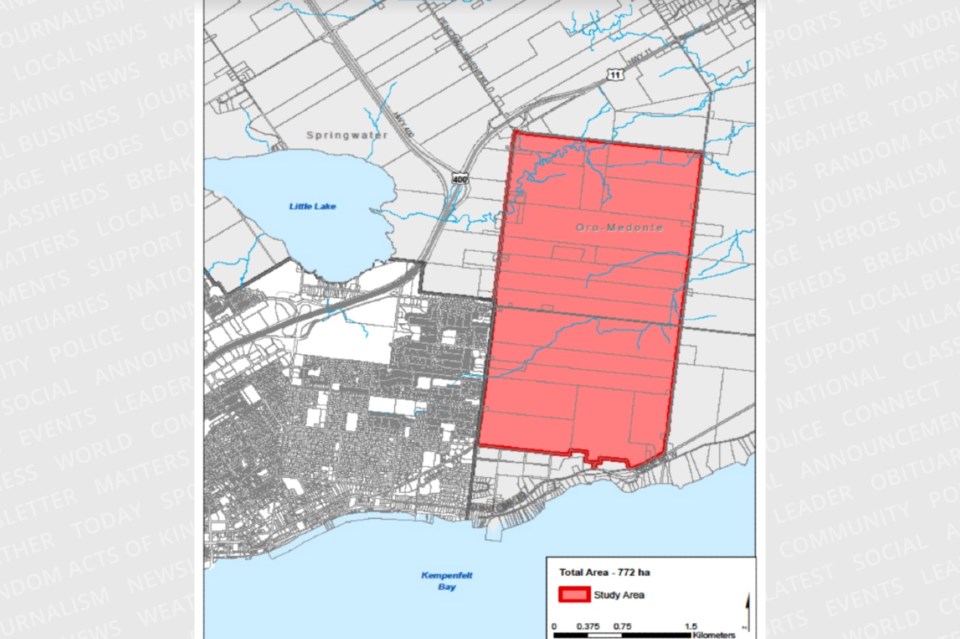
Since that announcement, Nuttall has appeared before Oro-Medonte council to pitch his idea. During that presentation, township residents learned Barrie is looking at about 880 hectares (almost 2,200 acres) of Oro-Medonte’s land on the city’s eastern border, including near Crown Hill in the area of Highway 400 and Highway 11.
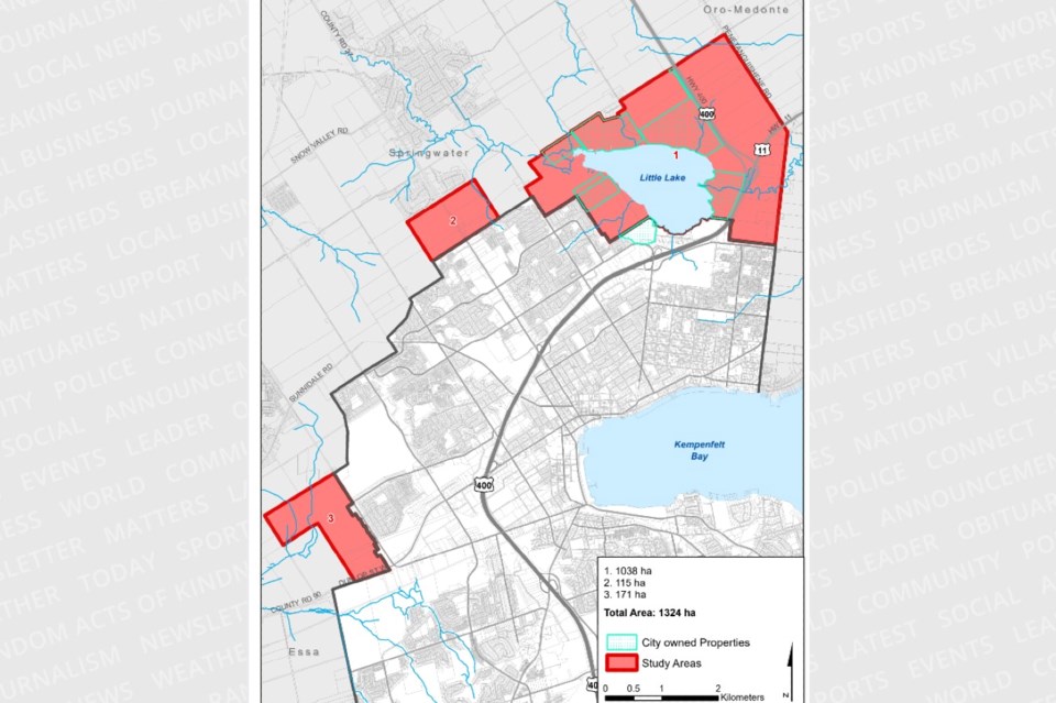
On Thursday night, Springwater Township posted a map on its website that shows what pieces of land in its municipality the City of Barrie is also interested in acquiring.
There are three specific parcels in Springwater.
Area 1 includes 1,038 hectares (2,500 acres), Area 2 is 115 hectares (285 acres) and Area 3 is 171 hectares (420 acres).
Area 1 is located in the city’s northeast district and surrounds Little Lake, where the city currently owns a number of smaller parcels of land. The proposed boundary expansion would see the city grow out to Penetanguishene Road to the east and as far north as Partridge Road.
Area 2 includes the land from Bayfield Street west to Anne Street, and Bayfield Street east to St. Vincent Street, from Barrie’s northern limit to halfway to Carson Road.
Area 3 includes land bordered by Dunlop Street in the south, Miller Drive to the east, halfway north to Sunnidale Road and George Johnston Road at its most western point.
“As of now, no commitments have been made and no agreements have been established,” Springwater Mayor Jennifer Coughlin has said.
According to Nuttall, Barrie is in dire need of land that would be suitable for large-scale manufacturing and industrial development.
“We don’t have enough land to expand and grow, and we don’t have enough workforce to fill the jobs we need," he has said.
He said Barrie needs space to grow as a community and it needs space to bring in jobs from outside the region.
Springwater council will discuss Barrie’s proposed boundary expansion during the open session of council on Wednesday, Nov. 15. That meeting is scheduled to begin at 6:30 p.m. at the Springwater Township Administration Centre, located in Midhurst at 2231 Nursery Rd.
The Barrie-Innisfil Boundary Adjustment Act took effect on Jan. 1, 2010. Much of that land still remains undeveloped, although several projects continue to move along in various stages.