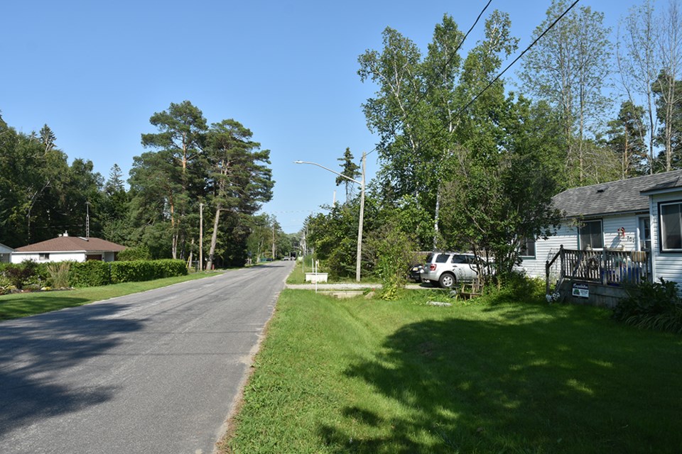
On a hot day in July, there is little water in the ditch along the south side of Park Road.
But it’s a different story after a heavy rainfall, or in the spring when the snow melts.
Then the ditch fills to overflowing, as torrents of water race towards Lake Simcoe – flooding low-lying properties and spilling over onto the road.
In 2019, the Town of Innisfil began a Schedule B municipal class assessment to look at drainage improvements that would reduce the risk of flooding, and reduce the number of contaminants carried into Lake Simcoe by the floodwaters.
In a now-completed Environmental Study Report, KSGS Engineering Corp. looked at various options to improve drainage conditions along Park Road, from 25 Sideroad east to the outlet into Lake Simcoe.
They concluded that while the low elevation of the land, proximity to Lake Simcoe, and high water table all were factors that contributed to flooding, the biggest issue was “external drainage.”
Runoff from 34.5 hectares of land west of 25 Sideroad has been channelled underneath 25 Sideroad, through two 600 mm culverts, entering an intermittent creek that flows through the woodlot at the northwest corner of Innisfil Beach Park.
The channel then cuts through private property, at numbers 747, 753, 759, and 767 Park Road, before joining up with the south ditch.
The ditch is not designed to carry the higher flows, the consultants concluded. The result is ponding and flooding of property.
In looking for a solution, KSGS considered options that included:
. Do nothing, which would leave the issues unresolved.
. Low Impact Development (LID), from green roofs to rainwater harvesting to soak-away pits. It was determined that LID would not have a significant impact on flooding, and in some cases was not feasible, due to the high water table.
. Regrade the south ditch and improve those driveway culverts that are undersized, corroded, clogged with dirt and weeds, or improperly placed. While helpful, the consultants concluded this would not be enough to handle the excessive external flows.
. Divert the external drainage to a new channel to be constructed through Innisfil Beach Park, behind the homes on Park Road. This option could, they concluded, reduce peak flows by approximately 60 per cent – and offer opportunities to enhance Innisfil Beach Park, by creating a naturalized channel with ‘pocket wetlands,’ improved natural habitat, native riparian landscaping, and a new pedestrian trail.
The preferred solution, as identified in the ESR, combines some regrading of the south ditch and replacement of culverts, with the construction of a diversion channel in the park - “the only option that provides a long-term solution to the problem,” the consultants noted.
There will be some loss of parkland, as a result of construction of the new channel, which would start behind 767 Park Road, and include construction of a berm to block the existing channel.
And of the 188 trees on town-owned in Innisfil Beach Park within the study area, the report noted that 48 will have to be removed, and another 12 will be damaged, in the construction of the channel. The trees to be removed include 16 white birch, 10 European red pine, seven white ash, and four willows.
A new pedestrian bridge is also planned, to carry foot traffic, from the Alderslea entrance to the park across the channel.
The estimated cost of the option was given at $1.5 million.
The ESR is now posted on the Innisfil website, for a 30-day “public and agency review and comment period,” and can be accessed by clicking here. Residents and interested parties have until Aug. 15 to comment; comments can be provided in writing to the Town of Innisfil Capital Project Manager, Amber Leal, CET PMP, 2101 Innisfil Beach Road, Innisfil ON, L9S 1A1, or email [email protected].
The consultants have proposed that the work be carried out in stages, during the “dry season” (July to September), to reduce the difficulty of dealing with the high water table, and to avoid bird nesting season.
Stage 1 would involve the installation of erosion controls, and excavation of the diversion channel in Innisfil Beach Park, while Stage 2 would be directed to cleaning out the existing outfall into Lake Simcoe.
Improvements to the Park Road ditches and driveway culverts would be part of Stage 3, and homeowners will be notified prior to work beginning in front of their properties.
The final stages would involve diversion of the flows to the new channel, and ongoing monitoring, to gauge the effectiveness of the project and watch for signs of erosion within the project.
The project, the study concludes, “will result in an overall net improvement to the natural conditions in the study area, and the prevention of flooding to property.”
The notice of completion was actually expected earlier this year. Amber Leal, capital project manager with the Town of Innisfil, explained the delay:
"The delay in issuing the Notice of Completion was to ensure all Town obligations with respect to the MCEA process had been met."
Now that the report has been released, if there are no appeals or requests for a 'bump-up' to a higher-level Environmental Assessment within the 30 day review period, "we will go to construction for Phase 1 this fall, if qualified tenders are submitted," said Leal.
She acknowledged that tendering has also been delayed somewhat. "We are delayed in issuing the tender as we work through some of the design considerations with the LSRCA (Lake Simcoe Region Conservation Authority)," Leal said.


